2 h 38 min, 115 mi, from 315 S Cache to Canyon General Store, Yellowstone OR
2 h 47 min, 114 mi, from condo to Canyon via Teton Park Road instead of 26
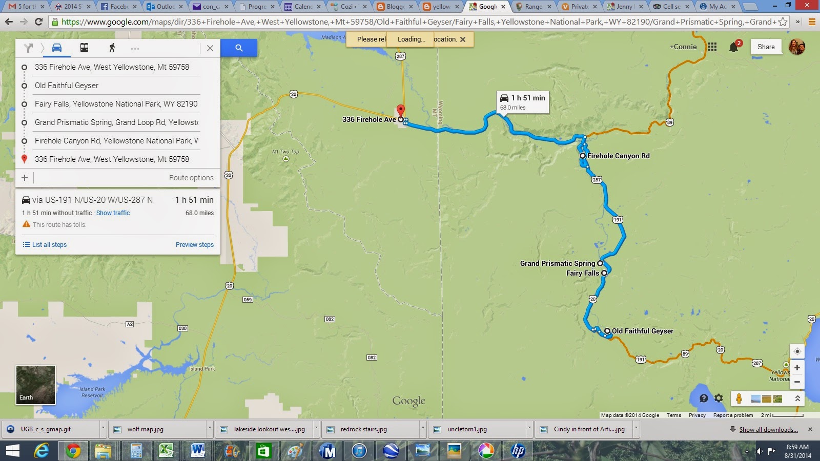
1 h 06 min, 40.9 mi from Lookout Point to 336 Firehole Ave.
Leave Jackson, 10a, arrive Canyon 12:30p, each lunch.
1:00 Uncle Tom's trail, 384 steps down, 384 steps back up, 500 ft elevation change, approx 45 min.
2:00 Brink of the Lower Falls trail, .4 each way, 600 feet elevation change.,
3:30 Lookout Point
4:00 head toward West Yellowstone
5:15 arrive West Yellowstone. Unpack, get groceries and dinner.

http://mms.nps.gov/yell/features/canyontour/map.htm

from:
http://www.trailguidesyellowstone.com/information/grand_canyon_of_the_yellowstone.php
I'd like to to Artist Point, Lookout Point, Uncle Tom's Trail and if the kids don't quit before then, Brink of the Lower Falls. That doesn't achieve the objective of getting away from the crowds, but as the only way to see the canyon is from the rim (with the crowds), or from the bottom (5 miles down, 5 back up, I'm not doing it with kids). Cafeteria and Lodge will be closed, we are on our own for lunch.
Canyon Village
| Facility | Opens | Closes |
| Canyon Yellowstone Adventure Store | April 18 | Nov. 3 |
| Service Station (Credit card fueling available all season) | May 2 | Oct. 20 |
| Wrecker Service | May 2 | Oct. 12 |
| Canyon General Store | May 16 | Sept. 29 |
| Repair Service | May 23 | Sept. 1 |
| Canyon Campground | May 30 | Sept. 14 |
| Canyon Lodge, Dining Room, Picnic Shop, Cascade & Dunraven Lodges, Western Cabins, Gift Shop | May 30 | Sept. 21 |
| Cafeteria | May 24 | Sept. 14 |
| Pioneer/Frontier Cabins | May 30 | Sept. 17 |
| Trail Rides | June 25 | Aug. 30 |

Note people standing next to falls

brink of the lower falls

328 steps ~= 25 flights of stairs.

people on the stairs of Uncle Tom's Trail.
 Purchase your self-guiding booklet for $5 at the Canyon Visitor Education Center or Old Faithful Visitor Center. You’ll investigate the mysteries of Yellowstone by completing activities in the visitor center and field. Young Scientist Toolkit, which has a thermometer, stopwatch, and other gear. Once your investigation is complete, you will be awarded an official Young Scientist patch or key chain.
Also, Junior Ranger program is available at Canyon Village: http://www.nps.gov/yell/forkids/upload/JR20128-12.pdf
Uncle Tom's Trail is a
quick but strenuous hike that ends near the base of Lower Falls in Yellowstone National Park.
Difficulty: Moderate
Length: 0.3 miles / 0.5 km
Duration: 1 hour or less
Family Friendly
Nestled between Upper Falls and Lower Falls, Uncle Tom’s Point is located along a bend in the Yellowstone River. Because of the bend, it is not possible to see both Upper Falls and Lower Falls at the same time.
For a leisurely walk to see Upper Falls plummeting 109 feet (33 m), follow the trail on your left. The viewpoint is approximately 100 yards (90 m) from here. You will find two platforms from which to see Upper Falls. From the overlook on your left, you can also glimpse Crystal Falls across the canyon.
Uncle Tom's Point: 44° 42.918′ N, 110° 29.783′ W. Marker is in Yellowstone National Park, Wyoming, in Park County. Marker can be reached from South Rim Drive 0.6 miles east of Grand Loop Road.
The steep, winding path to the Brink of Lower Falls overlook descends very rapidly about 600 feet (180 m) in 3/8 mile (0.6 km). You will encounter very steep grades, slippery gravel, and rough surfaces. Reaching the Brink of Lower Falls overlook requires hiking a steep trail that winds down the canyon wall…a wall of hardened rhyolite lava.
 Lookout Point (above) is popular for its lofty view. The minimum distance to Lookout Point is 0.15 miles round trip with 25 feet of elevation gain. From Lookout Point, a steep descent to Red Rock will take you to the North Rim's closest full view of Lower Falls. Please be prepared for steep grades, steps, and a rough surface. The trail descends rapidly—about 500 feet (150 m) in 3/8 mile (0.6 km). Red Rock Trail takes the hardy visitor close enough to feel the spray. To reach this trail from the parking lot, bear right on the paved walkway. The trail drops 500 ft (150 m) in about 3/8 mile. It is not recommended for visitors with heart,lung, or other health conditions.
Red Rock stairs:
Lookout Point (above) is popular for its lofty view. The minimum distance to Lookout Point is 0.15 miles round trip with 25 feet of elevation gain. From Lookout Point, a steep descent to Red Rock will take you to the North Rim's closest full view of Lower Falls. Please be prepared for steep grades, steps, and a rough surface. The trail descends rapidly—about 500 feet (150 m) in 3/8 mile (0.6 km). Red Rock Trail takes the hardy visitor close enough to feel the spray. To reach this trail from the parking lot, bear right on the paved walkway. The trail drops 500 ft (150 m) in about 3/8 mile. It is not recommended for visitors with heart,lung, or other health conditions.
Red Rock stairs:

Grandview
This stunning canyon is 23 mi long, but there is only one trail from rim to base. As a result, a majority of Park visitors clog the north and south rims to see Upper and Lower Falls. Unless you're up for the six-hour strenuous hike called Seven Mile Hole, you have no choice but to join the crowds on the rims to see this natural wonder.
Upper Falls 109ft high, Lower Falls, 308 ft high.
Three popular scenic overlooks line the one-way 2.5 mile North Ridge Dr: Lookout, Grandview and Inspiration points. Most visitors drive, but you can walk the North Rim Trail that parallels the road and continues .75 further to Chittenden Bridge on South Rim Dr, where it links up with the South Rim Trail.
"Brink of the lower falls" at the end of a steep .75 mile trail descending 600ft.
Lookout Point offers the best views of the Lower falls, and an adjacent .5 mi trail drops 500ft to Red Rock for even closer views.
Grandview Point: views of the canyon walls.
Inspiration Point: overview of the length of the canyon
Upper Falls viewpoint: less dramatic
South Rim:
'Artist Point: the canyon's most spectacular overlook. "Rangers give talks here 6 times a day with the 10a talk aimed kids.
South Rim Trail 3.25 mile
"Don't miss this, best sight and most breath taking sight in Yellowstone! Make sure you visit both the upper and lower falls cross the bridge to the other side. Make it point to go to all the sight stops to enjoy all this natural beauty"
"The hikes around the rim are very nice and easy to do with kids."
"If you stay at Canyon lodge and cabins there is a wooded path to Grandview point just 15 mins or so away, from there we walked the north rim. We spent 5 hours in total and it was worth every moment, even in the rain ! Plan to spend at least 2 or 3 hours to enjoy it. You can drive along the rim and stop at various viewpoints if hiking is not your thing."
"Hiked down to the brink of Lower Falls. Gorgeous!!! Must see from Artists Point on the South Rim. More impressive than Old Faithful"
"Take all the short hikes in the area."
"Be VERY careful though--many of the boardwalks and paths teeter on the edge of the canyon, hundreds of feet up and dozens of people have gone over, I've heard. Keep a close eye on your kids"
"Artist's point is by far the best view"
"There are excellent free ranger-led walks, which take you along the southern rim. These give you a lot of interesting information about the creation of the park and the canyon, as well as a certain degree of security from wild animals, such as the inquisitive bison that chose to follow our tour. The main viewpoints are very congested with coach parties and in the afternoon you will not get the best lighting conditions, so go early to beat the crowds."
"Make the trip to the lower waterfall' it's a tough way up using the almost 300 steps, but the view is impressive"
"There are car parks at the Upper Falls and at Artist Point, where there is a magnificent view of the canyon and the Lower Falls. Early morning is the best time to see the canyon and, if you have the time, it is possible to walk the trail at the top of canyon between these two points."
"You should allow 2 to 3 hours to tour this area. If hiking, you should carry bear spray for this is a bear area"
"The area is best appreciated by driving the rim drives and exploring the overlooks on each side"
"The falls that are taller than Niagara"
"We traveled in September when we know most kids would be back in school. Start out early in the day and plan on the parking lots being full by midday."
"We photographed from Artist's point, then walked down the trail to Uncle Tom's Point for a spectacular view of the canyon. Well worth the walk."
"There are two sides of the canyon that can be explored. Make sure you see both; the views are completely different"
"We started our morning here. There was a beautiful rainbow at the falls. On the North Rim Drive, we saw the tops of the Lower Falls, Look out point and inspiration point. There were a couple of osprey nests on the rocks in the canyon. We saw the brink of the upper falls and then continued to the South Rim Drive, saw the upper falls viewpoint, artist point and walked down the paved incline and 300 steps of Uncle Tom's Point. It you are able to make the steps up and back it is worth seeing Uncle Tom's Point. It was very pretty."
"The South Rim and Artist's Point is probably the most breathtaking, but don't miss the North Rim where you can walk right down and get a close up of the falls. "
"When viewing Lower Falls, the overcrowded Uncle Tom's Point, despite being closest, is not actually the best view. Instead try the hike down from Lookout Point for a gorgeous view of Lower Falls, or Artist Point to take in both the falls and the canyon in a spectacular vista."
" Drive around to the south rim and go to Artists Point, amazing view along the canyon and the falls. Then head back to the north rim where you can walk right to where the water tips over."
Info about Brink of the Lower Falls:
"The trail to the top of the Falls (3/4 of a mile roundtrip, but steep with many switchbacks) is a must, as the experience of standing atop the Falls is one of the most breath-taking experiences in the entire Park." "Set out from the well-marked trailhead and follow the leftmost fork. You will descend a series of innumerable, paved switchbacks bordered by railing. About 0.15 miles into the route you will pass a small spur to your left. Unfortunately, this spot provides limited views of the canyon and little if any view of the falls; it serves mostly as a convenient pull-off for tired hikers on the way back up.
Your descent will conclude 0.25 miles later at a viewing platform that extends to the very edge of the falls, affording a nearly vertigo-inducing overhead view of the tremendous cascade as it plunges 308 feet. Watch for rainbows glittering in the spray, and soak in the magnificent views of the rugged canyon. Across the way, you will see the arcing metal stairs of Uncle Tom’s Trail, another well-known descent into this stunning gorge.
When you are ready, retrace your steps to your starting point. The return trip is inevitably strenuous"
Info about UNCLE TOM'S TRAIL:
"Offers the best views of the Upper and Lower Falls" " The end of the trails is not at the river but on a platform suspended about 4/5 of the way down." " I made the round trip from the parking area down to the bottom of the trail and back up in about 30 minutes and that was with 5 to 10 minutes at the bottom" "this was one the best stops we made at the falls" "I thought the view from the bottom of the steps is just as good as the view from the top. It wasn't worth the climb back up the steps." " It only took me 4 1/2 min to go down but 20 to climb back up it is very steep but the view of the falls are worth the pain" "Best view for the lower falls. You will get a real close view. Amazing opportunity for taking pictures." "Uncle Toms trail is pretty for sure, but given the other features near by (Lower Falls, canyon etc.) we felt we would not have regretted skipping it. " "There are 352 steps you have to climb down and back up, but if you can do it, do it! This offers an amazing view of the falls the whole way down and back up." "My family of 9 &12 yo boys, my hubby & I (40 yo) ventured down Uncle Tom's Trail - we were not disappointed. The 328 steps down were not overly difficult unless you have a fear of heights. I do. But I was not going to let that stop me from what is one of the most breathtaking (literally) views I have ever seen. "
Tower Roosevelt area and tower falls:
Tower Falls: If you stop at the place where it says "tower fall", you're at the wrong place. It doesn't offer you a great view, not good at all. You should rather keep your eyes alert when driving past tower - Roosevelt and stop onto the side wherever you see a great view.
Firehole Canyon:


There is a sign for the turn onto Firehole Canyon Drive,if you get to Madison Jcn, you went too far. 30 min, 17.9 mi from Grand Prismatic Spring parking. "We took this one-way road, and weren't disappointed. This drive is only 2 miles long but you get great views of the Firehole falls and there is a great swimming area" "There is also a place where you can park, go down a staircase and swim in the river." "Really unique wonder of nature . Beautiful canyon with rapids . The geological area very interesting to behold" "The firehold canyon drive is a picturesque and hilly (paved) road that leads to the swimming spot. There are a couple of basic toilets you can get changed in. A set of stairs leads you down to a small 'beach' area and some rocks where there is a natural pool of water you can swim in. If you are a strong swimmer (and/or willing to climb over the rocks) you can get upstream and then ride the current back, or go a little higher to jump in front of a small cascade which will similarly push you back down to the pool area. Would recommend sandals for the rocks. " "it was still cold at first. I took my six and eight year old up stream a hundred yards or so and floated down. It was a blast. My daughter couldn't get enough. We floated multiple times. It's great on a hot day " "Take the "Canyon Loop Drive", you'll need to go to the north end as it's One-Way, is the answer. drive slowly and keep a sharp watch on your right. You'll see parked cars pretty soon, where the Firehole widens out into a slow, flat run."
 from : http://www.trailguidesyellowstone.com/information/upper_geyser_basin_yellowstone.php


