Sunday, March 16, 2014

yellowstone canyon info

2 h 38 min, 115 mi,  from 315 S Cache to Canyon General Store, Yellowstone OR 
2 h 47 min, 114 mi, from condo to Canyon via Teton Park Road instead of 26
1 h 06 min, 40.9 mi from Lookout Point to 336 Firehole Ave.

Leave Jackson, 10a, arrive Canyon 12:30p, each lunch.  
1:00 Uncle Tom's trail, 384 steps down, 384 steps back up, 500 ft elevation change, approx 45 min.  
2:00 Brink of the Lower Falls trail, .4 each way, 600 feet elevation change., 
3:30 Lookout Point
4:00 head toward West Yellowstone
5:15 arrive West Yellowstone.  Unpack, get groceries and dinner.


Map of the Grand Canyon of the Yellowstone and surrounding area.
http://mms.nps.gov/yell/features/canyontour/map.htm
Canyon Area Trail Map - Yellowstone National Park from:  http://www.trailguidesyellowstone.com/information/grand_canyon_of_the_yellowstone.php

I'd like to to Artist Point, Lookout Point, Uncle Tom's Trail and if the kids don't quit before then, Brink of the Lower Falls.  That doesn't achieve the objective of getting away from the crowds, but as the only way to see the canyon is from the rim (with the crowds), or from the bottom (5 miles down, 5 back up, I'm not doing it with kids).  Cafeteria and Lodge will be closed, we are on our own for lunch.
Canyon Village
FacilityOpensCloses
Canyon Yellowstone Adventure StoreApril 18Nov. 3
Service Station (Credit card fueling available all season)May 2Oct. 20
Wrecker ServiceMay 2Oct. 12
Canyon General StoreMay 16Sept. 29
Repair ServiceMay 23Sept. 1
Canyon CampgroundMay 30Sept. 14
Canyon Lodge, Dining Room, Picnic Shop, Cascade & Dunraven Lodges, Western Cabins, Gift ShopMay 30Sept. 21
CafeteriaMay 24Sept. 14
Pioneer/Frontier CabinsMay 30Sept. 17
Trail RidesJune 25Aug. 30


Note people standing next to falls
brink of the lower falls

328 steps ~= 25 flights of stairs.
people on the stairs of Uncle Tom's Trail.


canyoncoverPurchase your self-guiding booklet for $5 at the Canyon Visitor Education Center or Old Faithful Visitor Center. You’ll investigate the mysteries of Yellowstone by completing activities in the visitor center and field. Young Scientist Toolkit, which has a thermometer, stopwatch, and other gear. Once your investigation is complete, you will be awarded an official Young Scientist patch or key chain.

Also, Junior Ranger program is available at Canyon Village: http://www.nps.gov/yell/forkids/upload/JR20128-12.pdf

Uncle Tom's Trail is a quick but strenuous hike that ends near the base of Lower Falls in Yellowstone National Park.
Difficulty: Moderate
Length: 0.3 miles / 0.5 km
Duration: 1 hour or less
Family Friendly

Nestled between Upper Falls and Lower Falls, Uncle Tom’s Point is located along a bend in the Yellowstone River. Because of the bend, it is not possible to see both Upper Falls and Lower Falls at the same time.

For a leisurely walk to see Upper Falls plummeting 109 feet (33 m), follow the trail on your left. The viewpoint is approximately 100 yards (90 m) from here. You will find two platforms from which to see Upper Falls. From the overlook on your left, you can also glimpse Crystal Falls across the canyon. 


Uncle Tom's Point: 44° 42.918′ N, 110° 29.783′ W. Marker is in Yellowstone National Park, Wyoming, in Park County. Marker can be reached from South Rim Drive 0.6 miles east of Grand Loop Road.

The steep, winding path to the Brink of Lower Falls overlook descends very rapidly about 600 feet (180 m) in 3/8 mile (0.6 km). You will encounter very steep grades, slippery gravel, and rough surfaces.  Reaching the Brink of Lower Falls overlook requires hiking a steep trail that winds down the canyon wall…a wall of hardened rhyolite lava.
Red Rock Point seen below
Lookout Point (above) is popular for its lofty view.  The minimum distance to Lookout Point is 0.15 miles round trip with 25 feet of elevation gain.   From Lookout Point, a steep descent to Red Rock will take you to the North Rim's closest full view of Lower Falls. Please be prepared for steep grades, steps, and a rough surface. The trail descends rapidly—about 500 feet (150 m) in 3/8 mile (0.6 km).  Red Rock Trail takes the hardy visitor close enough to feel the spray. To reach this trail from the parking lot, bear right on the paved walkway. The trail drops 500 ft (150 m) in about 3/8 mile. It is not recommended for visitors with heart,lung, or other health conditions.
Red Rock stairs: 


Grand View of the canyonGrandview

This stunning canyon is 23 mi long, but there is only one trail from rim to base. As a result, a majority of Park visitors clog the north and south rims to see Upper and Lower Falls. Unless you're up for the six-hour strenuous hike called Seven Mile Hole, you have no choice but to join the crowds on the rims to see this natural wonder.

Upper Falls 109ft high, Lower Falls, 308 ft high.

Three popular scenic overlooks line the one-way 2.5 mile North Ridge Dr: Lookout, Grandview and Inspiration points.  Most visitors drive, but you can walk the North Rim Trail that parallels the road and continues .75 further to Chittenden Bridge on South Rim Dr, where it links up with the South Rim Trail.  

"Brink of the lower falls" at the end of a steep .75 mile trail descending 600ft.

Lookout Point offers the best views of the Lower falls, and an adjacent .5 mi trail drops 500ft to Red Rock for even closer views.  

Grandview Point: views of the canyon walls.

Inspiration Point: overview of the length of the canyon

Upper Falls viewpoint: less dramatic

South Rim:
'Artist Point: the canyon's most spectacular overlook. "Rangers give talks here 6 times a day with the 10a talk aimed kids.

South Rim Trail 3.25 mile

"Don't miss this, best sight and most breath taking sight in Yellowstone! Make sure you visit both the upper and lower falls cross the bridge to the other side. Make it point to go to all the sight stops to enjoy all this natural beauty"

"The hikes around the rim are very nice and easy to do with kids."

"If you stay at Canyon lodge and cabins there is a wooded path to Grandview point just 15 mins or so away, from there we walked the north rim. We spent 5 hours in total and it was worth every moment, even in the rain ! Plan to spend at least 2 or 3 hours to enjoy it. You can drive along the rim and stop at various viewpoints if hiking is not your thing."

"Hiked down to the brink of Lower Falls. Gorgeous!!! Must see from Artists Point on the South Rim. More impressive than Old Faithful"

"Take all the short hikes in the area."

"Be VERY careful though--many of the boardwalks and paths teeter on the edge of the canyon, hundreds of feet up and dozens of people have gone over, I've heard. Keep a close eye on your kids"

"Artist's point is by far the best view"


"There are excellent free ranger-led walks, which take you along the southern rim. These give you a lot of interesting information about the creation of the park and the canyon, as well as a certain degree of security from wild animals, such as the inquisitive bison that chose to follow our tour. The main viewpoints are very congested with coach parties and in the afternoon you will not get the best lighting conditions, so go early to beat the crowds."

"Make the trip to the lower waterfall' it's a tough way up using the almost 300 steps, but the view is impressive"

"There are car parks at the Upper Falls and at Artist Point, where there is a magnificent view of the canyon and the Lower Falls. Early morning is the best time to see the canyon and, if you have the time, it is possible to walk the trail at the top of canyon between these two points."

"You should allow 2 to 3 hours to tour this area. If hiking, you should carry bear spray for this is a bear area"

"The area is best appreciated by driving the rim drives and exploring the overlooks on each side"

"The falls that are taller than Niagara"

"We traveled in September when we know most kids would be back in school. Start out early in the day and plan on the parking lots being full by midday."

"We photographed from Artist's point, then walked down the trail to Uncle Tom's Point for a spectacular view of the canyon. Well worth the walk."

"There are two sides of the canyon that can be explored. Make sure you see both; the views are completely different"

"We started our morning here. There was a beautiful rainbow at the falls. On the North Rim Drive, we saw the tops of the Lower Falls, Look out point and inspiration point. There were a couple of osprey nests on the rocks in the canyon. We saw the brink of the upper falls and then continued to the South Rim Drive, saw the upper falls viewpoint, artist point and walked down the paved incline and 300 steps of Uncle Tom's Point. It you are able to make the steps up and back it is worth seeing Uncle Tom's Point. It was very pretty."

"The South Rim and Artist's Point is probably the most breathtaking, but don't miss the North Rim where you can walk right down and get a close up of the falls. "

"When viewing Lower Falls, the overcrowded Uncle Tom's Point, despite being closest, is not actually the best view. Instead try the hike down from Lookout Point for a gorgeous view of Lower Falls, or Artist Point to take in both the falls and the canyon in a spectacular vista."

" Drive around to the south rim and go to Artists Point, amazing view along the canyon and the falls. Then head back to the north rim where you can walk right to where the water tips over."

Info about Brink of the Lower Falls: 
"The trail to the top of the Falls (3/4 of a mile roundtrip, but steep with many switchbacks) is a must, as the experience of standing atop the Falls is one of the most breath-taking experiences in the entire Park." "Set out from the well-marked trailhead and follow the leftmost fork. You will descend a series of innumerable, paved switchbacks bordered by railing. About 0.15 miles into the route you will pass a small spur to your left. Unfortunately, this spot provides limited views of the canyon and little if any view of the falls; it serves mostly as a convenient pull-off for tired hikers on the way back up.
Your descent will conclude 0.25 miles later at a viewing platform that extends to the very edge of the falls, affording a nearly vertigo-inducing overhead view of the tremendous cascade as it plunges 308 feet. Watch for rainbows glittering in the spray, and soak in the magnificent views of the rugged canyon. Across the way, you will see the arcing metal stairs of Uncle Tom’s Trail, another well-known descent into this stunning gorge.
When you are ready, retrace your steps to your starting point. The return trip is inevitably strenuous"

Info about UNCLE TOM'S TRAIL: 
"Offers the best views of the Upper and Lower Falls" " The end of the trails is not at the river but on a platform suspended about 4/5 of the way down." " I made the round trip from the parking area down to the bottom of the trail and back up in about 30 minutes and that was with 5 to 10 minutes at the bottom" "this was one the best stops we made at the falls" "I thought the view from the bottom of the steps is just as good as the view from the top. It wasn't worth the climb back up the steps." " It only took me 4 1/2 min to go down but 20 to climb back up it is very steep but the view of the falls are worth the pain" "Best view for the lower falls. You will get a real close view. Amazing opportunity for taking pictures." "Uncle Toms trail is pretty for sure, but given the other features near by (Lower Falls, canyon etc.) we felt we would not have regretted skipping it. " "There are 352 steps you have to climb down and back up, but if you can do it, do it! This offers an amazing view of the falls the whole way down and back up." "My family of 9 &12 yo boys, my hubby & I (40 yo) ventured down Uncle Tom's Trail - we were not disappointed. The 328 steps down were not overly difficult unless you have a fear of heights. I do. But I was not going to let that stop me from what is one of the most breathtaking (literally) views I have ever seen. "
Tower Roosevelt area and tower falls:
Tower Falls: If you stop at the place where it says "tower fall", you're at the wrong place. It doesn't offer you a great view, not good at all. You should rather keep your eyes alert when driving past tower - Roosevelt and stop onto the side wherever you see a great view. 
Firehole Canyon: 


There is a sign for the turn onto Firehole Canyon Drive,if you get to Madison Jcn, you went too far.  30 min, 17.9 mi from Grand Prismatic Spring parking.  "We took this one-way road, and weren't disappointed. This drive is only 2 miles long but you get great views of the Firehole falls and there is a great swimming area"  "There is also a place where you can park, go down a staircase and swim in the river." "Really unique wonder of nature . Beautiful canyon with rapids . The geological area very interesting to behold" "The firehold canyon drive is a picturesque and hilly (paved) road that leads to the swimming spot. There are a couple of basic toilets you can get changed in. A set of stairs leads you down to a small 'beach' area and some rocks where there is a natural pool of water you can swim in. If you are a strong swimmer (and/or willing to climb over the rocks) you can get upstream and then ride the current back, or go a little higher to jump in front of a small cascade which will similarly push you back down to the pool area. Would recommend sandals for the rocks. " "it was still cold at first. I took my six and eight year old up stream a hundred yards or so and floated down. It was a blast. My daughter couldn't get enough. We floated multiple times. It's great on a hot day " "Take the "Canyon Loop Drive", you'll need to go to the north end as it's One-Way, is the answer. drive slowly and keep a sharp watch on your right. You'll see parked cars pretty soon, where the Firehole widens out into a slow, flat run."

Friday, January 17, 2014

Airfare and car rental prices

As of 1/13/14, Alamo, full size $326/week ($47/day) via kayak.
Alamo, mid size SUV $444/week
Alamo, mini van $444/weeks (airportrentalcars.com)
Avis says "sold out" for the location on that date ??!!
expedia.com has the same rates for Alamo, with higher rates for Hertz, National, and Enterprise
National, $402/week full size car, $497/week std suv, $497/week, mini van, nationalcar.com
Thrifty says no rates available for one-way.
Air:
$507 United BWI 4:11p, JAC 8:35p 6h 24 m 1 stop (DEN) (would get the kids to bed abt midnight EST)
                    BIL 10:22a, BWI 6:14p, 5h 52 m 1 stop (DEN)
Same flight on 5/10- 5/17 $466.  Mar 1-8 $609. Apr 5-12 $517.
$548 United DCA 8:35a - 12:47p, BIL 10:22a - 6:14p.
$597 Delta BWI 7:20a, JAC 12:08p, 6h 48m 1 stop (SLC)
         BIL 6:20a, BWI 1:48p 1 stop (MSP)
Same flight on a Saturday in June 21-28, $807.  May 10-17 $459.  April 5-12 $434. Mar 1-8 $642.


Tuesday, October 15, 2013

things to do in the Tetons

Jackson is at an elevation of 6250ft.  We'll do no hiking the day of arrival, and sleep at elevation, starting to get used to it.  

Park entrance fees are $25 per car, truck, or RV; good for seven days in both Grand Teton and Yellowstone parks. Annual park passes are $40.

Map of the park: http://www.nps.gov/grte/planyourvisit/upload/GRTE_park_map_2011.pdf

Junior Ranger program for the kids: http://www.nps.gov/grte/forkids/upload/Grand-Adventure-13.pdf  To get a junior ranger badge, the kids must listen to at least one ranger led talk, and then either a 2nd, or see a video.  At Jenny Lake there are 2 programs, each done once per day.  One is bear safety, the other is variable.  Oxbow bend wildlife watch, 6p-7:30.  "Teton Topics" at Colter Bay, 30 min, once per day.  Preserve: 9:30, 3 mile ranger led walk.  Exact times are listed in the park news paper: http://www.nps.gov/grte/parknews/newspaper.htm


17.5 mi, 32 min condo to Rockefeller Preserve
5.2 mi, 15 min, Rock Preserve to Menor's Ferry
3.7 mi, 11 min, Menor's Ferry to Mormon Row
7.8 mi, 19 min Rock Pres to Mormon Row directly (saves 7 min)
11.6 mi, 25 min Rock Pres to Jenny Lake Visitor's Center
20.9 mi, 34 min condo to Jenny Lake Visitor's Center
26.5 mi 45 min, jenny lake vis cen to Leek's Marina via jenny lake loop road
20.2 mi, 32 min, jenny lake vis cen to Leek's Marina SKIPPING jenny lake loop road 
29.4 mi, 41 min, Leek's Marina to Craig Thomas Visitor Center (wildlife caravan)
7.7 mi, 13 min, jenny lake vis cen to Craig Thomas Visitor Center (wildlife caravan)
15.3 mi, 28 min, jenny lake vis cen to craig thomas vis center via loop road
16.1 mi, 35 min, Jenny Lake vis cen to restaurants in Jackson Hole
8.9 mi, 25 min, Jackson Hole restaurants to Craig Thomas Vis Center

sunday
9a hit the road
9:30a arrive Laurence Rockefeller Preserve
10:30a leave LRP
11:00a arrive Jenny Lake Ferry
11:45p start hike
3:30p finish hike, catch return Ferry
4:00 drive to Leek's marina for pizza OR drive to village cafe for pizza
5:00 Craig Thomas Visitor Center for wildlife caravan (reservations required, 10 vehicle max)
Cascade Canyon Trailhead 

To get to the Jenny Lake Visitor Center, enter Grand Teton National Park from Moose Junction and take the main park road north past Menors Ferry Historic District and the Chapel of the Transfiguration. Jenny Lake is on the left, about 8 miles from Moose Junction. The trailhead is located at the mouth of Cascade Canyon and can be accessed by taking the easy, 3.3 mile (one-way) Jenny Lake Loop or by taking the shuttle boat across the lake.

Sept 2-21 the shuttle runs 10a - 4p: Shuttles run every 10-15 minutes throughout the day. The last boat will leave the dock at the posted closing time.
Shuttle Rates for 2014:
Adult Round Trip        $15
Adult One Way          $9

Child Round Trip        $8
Child One Way          $6

Hidden Falls is on the way to Inspiration Point
Inspiration Point
  • 5.8 miles round-trip (2.2 miles with boat shuttle)
  • 4 hours (2.5 hours with shuttle)
  • 700 feet elevation gain
  • Moderate to Strenuous out-and-back
The hike to Inspiration Point: 


Cascade Canyon notes:
Cascade Canyon is the #2 activity in GTNP on Trip Adviser (behind "Grand Teton")

The last ferry leaves the trailhead site for the return to the visitor at 4pm so if you miss it don't stress as this part of the walk can be done in about an hour and is fairly easy with a couple of moderate climbs only.

The first half mile of the Cascade Canyon trail is moderate to steep climb over some rough terrain to Inspiration Point lookout. About a further 10-15 minutes on from here the trail flattens out to any easy walk along the valley floor for the next 2 miles or so thru stands of pines and open meadows. The valley is quite wide here and there are excellent views of the surrounding peaks and a number of cascading waterfalls entering the valley from the sides.
At the end of the valley the trail forks and then there is a moderate uphill climb for about 2.5 miles to Lake Solitude. 

The climb to Inspiration Point is not easy; the trail is rocky, but the views back across the lake and up the canyon are incredible.

If you make it all the way up to Inspiration Point don't turn back after checking out the view. The best is yet to come and you've already come through the most strenuous part of the trail. There's nothing quite like seeing the canyon open up before you as you walk further up the trail. You can choose how far you want to go into the canyon based on your energy levels but definitely go at least an extra 15-30 minutes into the canyon to take in the magnificent views. It's easy to understand why this is one of the most popular and beloved hikes in Grand Teton

“Our favorite activity in Grand Teton was this hike!”

Wildlife CaravanTravel with a ranger to look for wildlife during the early evening; the best viewing time. Be prepared to drive or ride to multiple locations. Dress warmly and bring binoculars or spotting scopes. Limited to 10 vehicles. Reservations are required. Please call the Craig Thomas Discovery and Visitor Center, (307) 739-3399, or make reservations in person. Ride sharing will be strongly encouraged. Meet at the Craig Thomas Discovery & Visitor Center in Moose at 5 pm. The tour lasts 3 hours.

Mormon Row Barns is a amazing spot for photos. It is "most photographed barn in America"

Fodor's recommendation for GT in one day: http://www.fodors.com/world/north-america/usa/wyoming/grand-teton-national-park/travel-tip_2295643.html

Go to the visitor center (it is very good) and take the scenic loop drive.

The have a cycling trial from Jenny Lake Area all the way to Jackson village which must be close to 30 miles long. The trail is mostly flat with great scenery all the way

 Drive Teton Park Road ( the loop road) for breathtaking views from the top of Signal Mountain and the Jenny Lake Overlook. 

September is probably the best month of the year to see the park. The colors turned from green to autumn in one week.

Moose Wilson Road is loaded with wildlife. Black Bear and Moose  "Would you believe that bears consume up to 20,000 calories a day in the fall? This feeding-frenzy is called “hyperphagia.” Bears put on weight in fall to survive winter hibernation. Hawthorne and chokecherry bushes line the Moose-Wilson Road providing prime habitat for both black and grizzly bears. Park rangers will close this road if necessary due to bear activity"

There is an excellent loop road that takes you along the bottom of the range through Moose, South Jenny Lake, North Jenny Lake, Jackson Lake Lodge, make sure that you do the Lunch Tree Hill walk at the back of the lodge, takes about 30 minutes and you will not be disappointed, then return back through Antelope Flats, we took the whole day as there are many turnouts where you can take photos.

 Don't miss the Rockefeller Nature Preserve

Spectacular views. Lots of wild animals to see. I had no idea what to expect and we actually saw more animals here then in Yellowstone. The view of the mountains is amazing no matter where you are in the park. We used a tour guide one day to show us where to find the wildlife and that was very helpful. 

The best way to see the beautiful mountains is to wait for the sunset somewhere around Jackson Lake


Jenny Lake Overlook: The Jenny Lake Overlook is probably the best vantage point to see the Teton Mountain Range directly behind Jenny Lake in Grand Teton National Park.  It's a fantastic view, and the only way to get there is to take the North Jenny Lake Junction road off of the Teton Park Road, and take the Jenny Lake Scenic Drive (one-way) just before you reach String Lake.

42 mile scenic loop notes: 
If you have but only one day in the Grand Tetons, definitely take this drive. Forty-two miles sounds short but with all the stops and beautiful photo opts, you can use the whole day. Take a picnic along as there aren't many places to eat. Take the Moose-Wilson Road (which turns to gravel for a short distance) if the road is open. This is where we saw the only bear the entire week. The Moose Visitor Center has a great exhibit area, food, and nice restrooms.

Outstanding photo ops around almost every corner. The Snake River Overlook was gorgeous. Lots of wildlife on both loops. It is only about a 4 hours trip to cover everything.

 we took 4 hours and didn't stop at all places.

 We particularly enjoyed the views from Jenny Lake. A ranger there had some wolf skins and was giving a talk about wolves in the park. 

If you want to see wildlife, do this drive. 

Do the speed limit! Federal speeding tickets issued in the park and they are ON it!

Having been to 45 states, I can say I've been to many of America's most beautiful places. This route is on the top of my list and has to be my favorite. Like the Teton Park Road, it is rarely mentioned as a great American drive but without question, it is one of the most scenic, tranquil drives you can ever take. Just be sure to take your time, you'll want to spend 4 or 5 hours absorbing the views.

There is plenty to do, primarily around Jenny Lake but we also ventured further north and went up Summit Mountain road where we saw a bear walking along the edge of the road minding his own business. This was our only sighting of bear on our whole trip but it was such a good one and totally unexpected. The view from the top of the mountain is great and so was the valley below.

Jackson Lake lodge has stunning views over the lake to the mountains beyond (someone else said there is a great breakfast here).

Our best view of the Tetons was actually outside the park on the main road at the Snake river overlook. Just up from Gros Venture junction on the Kelly road is a small pullout overlooking the river. Here we were told was a good place to see moose and we went at 7pm on 2 nights and both evenings we saw moose. We ate at Dornan's one evening just by the south entrance. They have a no frills pizza and pasta restaurant where the food is excellent.


Highlights
Be sure to grab a map at the park entrance. Here are some of our favorite stops (starting at Moose).
  • Chapel of the Transfiguration: This unique and very tiny church has a perfect view of the Tetons.
  • Menors Ferry: Ride the Menor's Ferry replica with a park ranger (only 15 minutes). ( the ferry doesn't run very long and it's really just luck if you can catch it...look through the cabin, transport shed and finally the store and cabin. Located on the side of the river, it gives you an insight to how pioneer life must have been, ) 
  • Jenny Lake Boat to Hidden Falls: Turn off at the South Jenny Lake Junction and ride the Jenny Lake Boat across the lake. Hike the short steep trail up to Hidden Falls (and beyond if you like).
  • Jenny Lake Loop Road: Further north, you can access the Jenny Lake Loop Road which runs one-way. It's a scenic jaunt off the main road.Jenny Lake Loop Grand Teton Park
  • Signal Mountain Road: From Signal Mountain Lodge, drive to the top of Signal Mountain for spectacular views of the Teton Range.
  • Oxbow Bend: This is a prime wildlife viewing location  .
  • Snake River Overlook: A beautiful view overlooking the Snake River.
  • Schwabacher Landing: Yet another stunning view of the Tetons.
  • Mormon Row: Turn east onto Antelope Flats road and discover a historic homestead at Mormon Row.
  • Dornan's: Grab a drink and head to the upper deck. It's a must stop at the end of a day in the Tetons. 
  • Moose-Wilson Road: As an alternative route back to Jackson, drive the scenic and wildlife-filled Moose Wilson Road.
Oxbow Bend
 If you can get there in late September, the Fall colors of the Aspen trees are beautiful as they reflect on the water there.  is just a turnout off the highway along the Snake river that offers great reflection shots of the Tetons. It is usually crowded, especially at sunrise although we did find a parking space.   is just a turnout off the highway along the Snake river that offers great reflection shots of the Tetons. It is usually crowded, especially at sunrise although we did find a parking space.  

Laurance Rockefeller Preserve Notes: 
The hike around Phelps lake is spectacular. Saw bears near the parking lot.  


offered good exposure to wildlife (in our case bull elk and black bear) and offers hiking options which are not too difficult.  Trail map: http://www.nps.gov/grte/planyourvisit/upload/Death_Canyon_topo.pdf

It is a great drive, a lot of wildlife to see-bears, elk, deer and beaver houses!!! There is a great place to pull over and look for moose also. Entrance off Moose-Wilson Rd. Parking is limited and you may have to wait your turn. The 2 hiking trails to Phelps Lake are very popular and form a loop of about 3-4 miles total. Enjoyed the visitors center and library.

The Moose-Wilson road is on the left just before the entrance to the Teton Park If you take the road to the end be prepared for tar to dirt and big potholes, but beautiful!!! You will end up just outside Teton Village and some amazing shots of the mountains. Caution--there are bears and quite a lot of them!!!!

But the bears were there and easy to find and watch. They were munching away on berries and leaves so were unconcerned about the people watching them. Saw a beautiful black bear crossing a small waterfall, then a cinnamon black bear up a tree eating.

 Numerous bears were back of the main building getting their last bits of the berries. The paths immediately around the preserve have berry bushes right up to the path so you should be careful for bears while walking through. We took a hike up to Phelps Lake, which was comfortable walk of approximately 3 miles round trip.


  • Address: On east side of Moose-Wilson Rd., about 4 mi south of Moose and 3 mi north of Granite Canyon Entrance Station, Grand Teton National Park, WY 83012

Jackson Hole Aerial Tram Ride: $74 for the 12 min tram ride to 10,450 ft, plus $12 parking.  That is a lot of money, and the kids may not be comfortable at that altitude.
One of the highlights of our trip! Of course we were there for the first snow of the year, and we are from Florida! Best view! At the top, beer, hot chocolate or hot waffles. ... Look in local flyers for discount coupons. $54 for 2 adults after the discount, but worth every penny!!

only took about 12 minutes to get to the top. get a full view of the valley and beyond. you can stay and hike around the trails, or ride back down

Kid price is $10, adult price is $26, if bought on-line in advance.  

The views are incredible on the way up but even more amazing when you get off at the top. You can see 360 degrees for what seems like forever. 

The tram is run efficiently. It takes about 15 minutes each way. The views are stupendous. Be sure to wear a jacket and hat and gloves as it is very cold up on top.

There are $5.00 off coupons in the local paper which makes the cost about $27.00 per person. You can also ride the chair lift for free after 4:00 pm. It takes you up to a nice bar and restaurant with outdoor seating for a grand view. Definitely worth the trip.

In 2013 is open until Sept 29.  $6 discount for tickets bought on line: http://www.jacksonhole.com/summer-ride-the-tram.html

This Tram Ride from Teton Village, WY will take you to the top of Rendezvous Mountain at 10,450 feet with great views There is paid parking everywhere in Teton Vilage with the lot for the tram currently at $12 for the day.


Alpine Slide:
Our kids enjoyed this quite a lot! You can either let it rip, or pull the brake and go slowly! If you are in the area, it is worth the time. I think we spent maybe 1 hour there signing up, and completing a run (you have to take the lift up, then wait a bit.)

 It's $15 a go but when you buy 4 tickets together you effectively get a 5th one free. You get a ski lift up and then get in a little toboggan and slide down the track. You can go as fast or as slow as you want! The kids seemed to be loving it! It was good fun but it would be better if it was a little less expensive. We still enjoyed it though and I would recommend it.  https://www.youtube.com/watch?v=bC1a5XU8RJw

 They do comp you one ride, for every four purchased, 

 But the kids loved it though...while on vacation, that is the most important part, right?

At first we though it was a little pricey at $15 per head, but the ride up on the ski lift and the fast but fun 2 minutes ride down the course was worth it and a lot of fun.

Jenny Lake scenic drive: 
This 4-mi, one-way loop provides the park's best roadside close-ups of the Tetons as it winds south through groves of lodgepole-pine and open meadows. Roughly 1.5 mi off Teton Park Road, the Cathedral Group Turnout faces 13,770-foot Grand Teton (the range's highest peak), flanked by 12,928-foot Mt. Owen and 12,325-foot Mt.

Junior Ranger Program:
Children ages 8-12 learn about the natural world of the park (GT) as they take an easy 2-mi hike with a ranger. Kids should wear old clothes and bring water, rain gear, and insect repellent. The hike, which takes place at Jenny Lake, is 1½ hours long and is limited to 12 children.

Signal Mountain Rd notes:
A 5-mile scenic mountain drive.

Views were nice but not all that spectacular.

 there were toilets at the top of the road! Spend some time on this road, drive slowly and you will be rewarded.

 the views weren't that breathtaking. At the top, you'd be looking in a direction opposite to the Tetons. It's an interesting view (vast), but I wish we had spent that time on foot instead of in the car. The road is good enough, it's paved and goes through forest. Probably took us less than an hour.

For sunset don't go all the way to the top. There is a turnout just a couple of turns before the top.

This is a winding road up the mountain which summits to a beautiful view of the valley and mountains. Breathtaking. There is a little "trail" to the right which allows a better view of the Tetons and an excellent photo opportunity. Absolutely worth the trip up. (And you get cell service here)

 While the main view seemed to be East, we did walk down the short trail to a viewing spot of the Tetons to the southwest.

Scenic Restaurant view.  Food and service were great.

It's a few mile drive to the overlook. When you walk up to the placard, you see some nice views, but keep walking out on the trail about 50-75 feet further for a spectacular view of Jackson Lake and the Tetons...spectacular!!!!

Schwabacher Point:
I've taken many pictures at Schwabacher Landing over the years, but to my dismay, the road is closed this year! Sequestration strikes again! 

The road to the landing is closed this year due to the sequester. However, you can still park on the highway and walk there, about 3 miles RT.

Fodor's recommends Jackson Lake Lodge for dinner: but the lodge gets so-so reviews on trip advisor etc.  The best reviewed place is Leeks Marina and pizzeria: 

http://www.lib.utexas.edu/maps/topo/wyoming/txu-pclmaps-topo-wy-grand_teton-1899.jpg
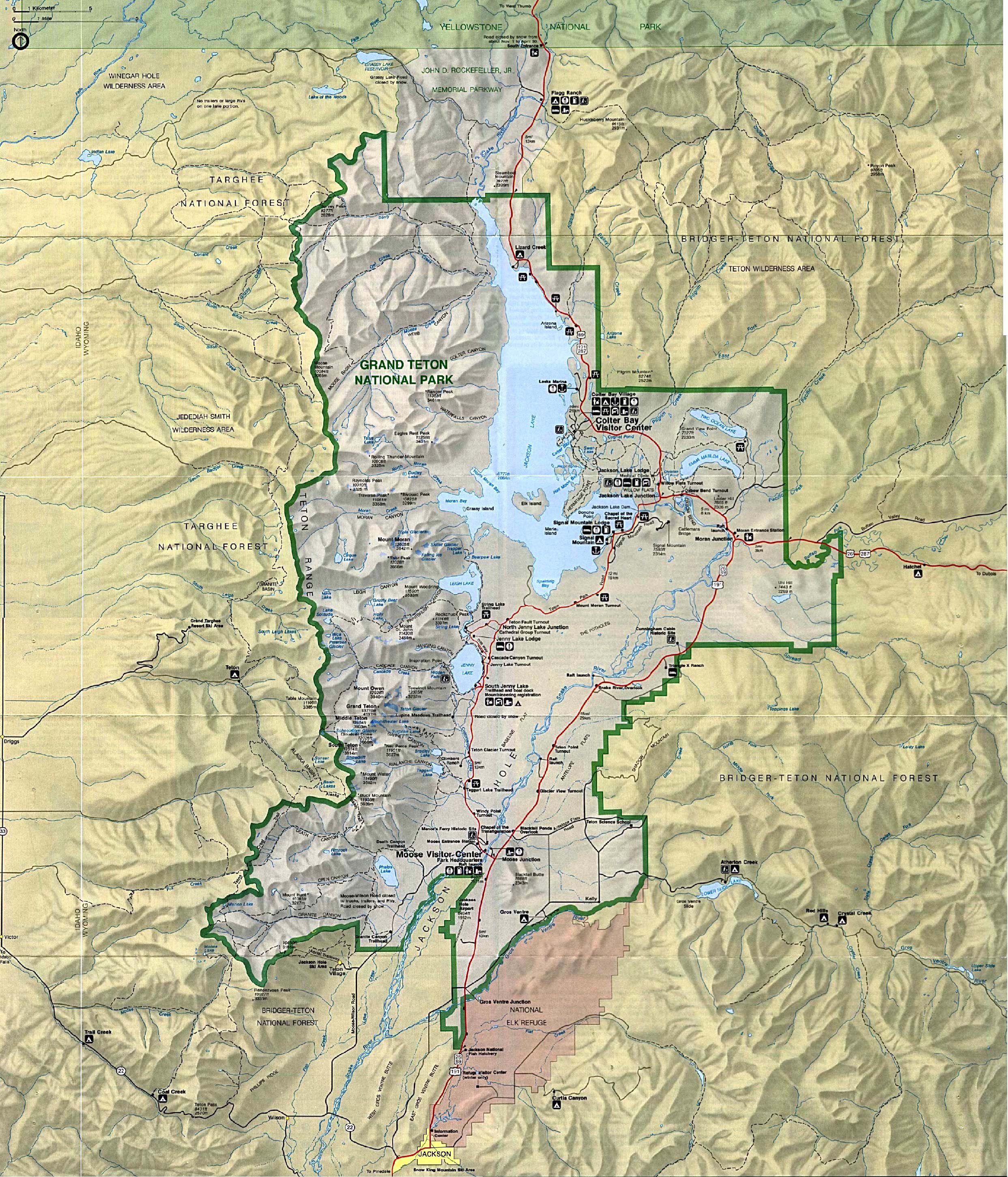


On the way to Yellowstone: 
a quick stop at Lewis falls for a leg stretch (very pretty).  It is 1 hr 21 min from the rental house, most of the way to Yellowstone Lake.  Looked at pictures, these falls are small and boring


Sunday, October 13, 2013

Costs

My original cost estimation from Feb 28, 2013: "So, Sept 21, 2014 I'd like to go to Yellowstone.  I found this 8 bedroom cabin that sleeps 18 for $399/night: http://www.faithfulstreetinn.com/cabins.php

Looks like in 2013 flights are about $550/pp round trip BWI to Jackson, WY.  Each family could rent a Subaru Outback or equivalent for $338/week.

If we get 4 families, the total for each family would be
$0 - meals and booze, assume we'd eat and drink like we would at home
$2200 - air, $550 x 4 tickets
$100- extra bags
$350 - rental car
$850 - 1/4 of 4 day house rental with tax
$25 - 7 day park pass
________________________________________
$3525 Grand total " <---- from my original e-mail, these were my old guestimates

Now we are down to 3 families.  I think I meant "1/4 of a 7 day house rental".  

The house in West Yellowstone is $379/night for 4 nights plus 10% tax, cleaning fee is included in the nightly rate so $1668/3 = $556.    The house rental near the Tetons is between $253 and $496, with the sweet spot (price/ft2/location) at $315/family.

The total expenditure EXcluding accommodations is $2200 + 100 + 350 + 25 = $2675

Accomodations:
$315 Jackson 2 nights (we'll have the place for 3 nights)
$556 West Yellowstone 4 nights
$85 Yodeler in Red Lodge, MT, one night.
$956 total for accommodations

$3631 for the new grand total

I think my flight prices were based on Sept 2013 numbers.  Only Delta and United fly into Jackson Hole Airport (JAC).  Right now the furthest date Delta is selling for is end of August at which time a flight BWI-JAC, and then BIL-BWI is $506.10 including taxes and fees.


Wednesday, August 28, 2013

Travel Time Compare

I want to revisit the lodging options before we book.  We had been planning the following sight-seeing itinerary:
day 1 arrive
day 2 Tetons
day 3 Tetons (or start Yellowstone exploring early to allow for a bad weather day mid-week)
day 4 Old Faithful and surrounding
day 5 Yellowstone Canyon and surrounding
day 6 Mammoth area and Fire Hole canyon hot springs
day 7 Lamar Valley
day 8 Bear Tooth Highway on the way to Billings Logan Airport

Tetons are 2 hr 24 min from West Yellowstone, and West Yellowstone is
To Jackson Airport (JAC) 2 hr 39 min
To Billings Logan Airport, 3 hr 50 min
To Bozeman MT (BZN), 1 hr 47 min from various airports, so we started to consider breaking the week up into 3 parts with different rental houses for different areas of exploration instead of just having one place near the parks, and one place near the Bear Tooth Highway.

Option 1, (called "staying 3 places") fly into Jackson (JAC), stay in chalet in Jackson Hole 1st 3 nights, house in West Yellowstone 2nd 3 nights, last night in Cooke City, leave via Billings Logan Airport

Options 2, (called "2 hotels") fly into Jackson (JAC), stay in Grant Village 1st 6 nights, last night in Cooke City, leave via Billings Logan Airport

compare:

driving times: staying 3 places: 14 hr 33 min,                          2 hotels: 18 hr 39 min
lodging costs: staying 3 places:  Idaho: 253
                              West Yellowstone 556                                 Old Faith Snow Lodge: $990
                      Lupine Inn (Red Lodge) 125                                 Lupine Inn (Red Lodge) 125
                           Total for 3 places    $934                                Total for 2 places $1115
times spent unloading and loading cars: checking in/out and loading unloading cars
                      staying 3 places: sat, tues, fri = 4 + 4 + 4hr        2 hotels: 4+ 4hrs (sat, fri)
(IMO we easily spend 2 hours unloading, figuring out who gets which room, finding toothbrushes, etc)
cost saved by having a kitchen: staying in 3 places: -$220
($20/breakfast X 5 breakfasts, $30/dinner X 4 dinners)
intangible benefits: 3 places: living room in which kids play together while adults drink and plan
                            2 hotels: one less time packing and unpacking could reduce stress

Option 1
day 1:  17 min driving, 2 hours unpacking = 2 h 17
day 2: 1 hr 8 min driving
day 3: 1 hr 8 min driving,
day 4: 2 hr packing, 3 hr 21 min driving, 2 hr unpacking = 7 hr 21 min not sight seeing
day 5: 2 hr 36 min driving
day 6: 3 hr 10 min driving
day 7: 2 hour packing, 2 hr 53 min driving, 2 hr unpacking = 6 hr 53 min not sight seeing
day 8: 2 hour packing, 2 hr 23 min driving to airport via Bear Tooth Highway, late flight

Option 2
day 1:  1 hr 31 min min driving, 2 hours unpacking = 3 hr 31 min
day 2: 2 hr 48 min driving
day 3: 2 hr 48 min driving,
day 4: 1 hr 6 min driving,
day 5: 2 hr 10 min driving
day 6: 3 hr 42 min driving
day 7: 2 hour packing, 2 hr 53 min driving, 2 hr unpacking = 6 hr 53 min not sight seeing
day 8: 2 hour packing, 2 hr 23 min driving to airport via Bear Tooth Highway, late flight